Surveying landslides around dam reservoirs
If the impounding of dam reservoir induces a landslide around its reservoir, it impacts not only the safety of the dam body, but also the functions of the reservoir and the preservation of the slopes around the reservoir, so it is important before impounding to study the possibility of landslide and take appropriate countermeasures in advance.
At the Japan Dam Engineering Center, as shown in the below figures, the landslide area is appropriately identified by topographical analysis using detailed topographical maps prepared by aerial laser surveying at the reconnaissance survey stage, then at the detailed survey stage, performing a detailed geological analysis using the latest geological investigation technologies such as high-quality sampling or bore-hole televisions, clarifying the landslide mechanisms and stability in order to propose appropriate countermeasure work.
At the Japan Dam Engineering Center, as shown in the below figures, the landslide area is appropriately identified by topographical analysis using detailed topographical maps prepared by aerial laser surveying at the reconnaissance survey stage, then at the detailed survey stage, performing a detailed geological analysis using the latest geological investigation technologies such as high-quality sampling or bore-hole televisions, clarifying the landslide mechanisms and stability in order to propose appropriate countermeasure work.
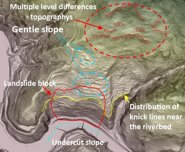
Shade diagram prepared based on an aerial laser survey diagram
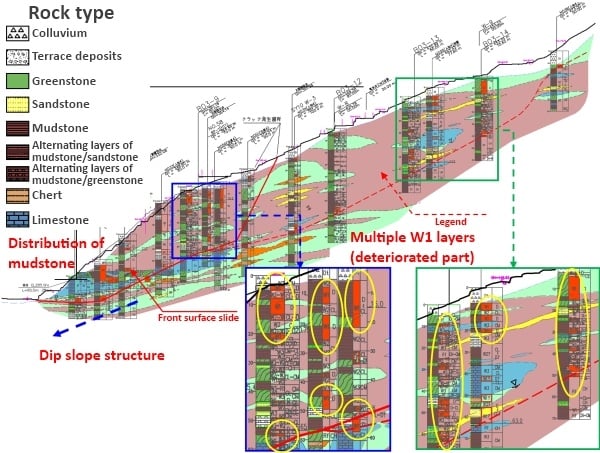
Initial landslide clarified by aerial laser survey diagram, high-quality sampling, and bore-hole televisions